⚒️ Southern Hemisphere Mining Limited reports continued encouraging results from expansion drilling at its Llahuin Copper-Gold Project in central Chile with laboratory results for the final fourteen holes of the seventeen-hole program have been received.
- Assay results of all recent drilling at Llahuin have been received demonstrating advancements in scale of the Project with all targets intersecting mineralisation.
- Significant intercepts include:
- 76m at 0.44% CuEq* in 23LHRD035 from surface, including 14m at 0.79% CuEq from surface
- 48m at 0.45% CuEq in 23LHRC042 from surface
- 12m at 0.66% CuEq in 23LHRC032 from surface
- 14m at 0.54% CuEq in 23LHRC029 from surface
- Significant intercepts include:
- The link between Ferro and Cerro is further advanced by drilling warranting additional drilling to understand the scale
- Potential Cerro-Ferro Root-Stock/Feeder zone concept advancing for future drilling
- 48m at 0.45% CuEq drilled Southeast of Ferro Deposit extends the Cerro-Ferro scale
- Mineralised system confirmed at the large Southern Porphyry target with up to 166m mineralised intercepts
*CuEq means copper equivalent grade, calculated from concentrations of molybdenum, gold and copper, as discussed in the JORC2012 table in the appendix.
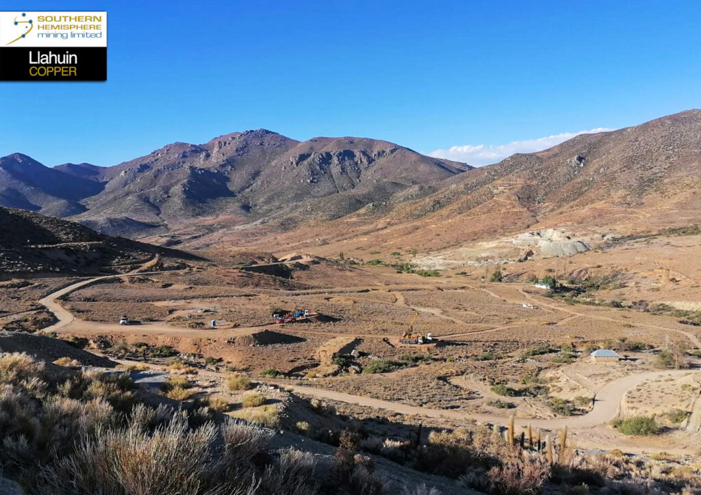
Figure 1. RC and Diamond rigs operating at Cerro De Oro with Central Deposit in the grey rock/workings on the right side of the valley
⚒️ Results Summary
1. The link between Cerro and Ferro is advanced by 23LHRD036, 23LHRC037, and 23LHRD043.
2. New drillhole grades continue to exceed historical grades in the Cerro and Ferro deposits, particularly with regard to the historical RC drilling.
3. Broad porphyry style mineralisation was intersected by two holes at the large greenfields Southern Porphyry target.
More detail on the drill results of each particular target are discussed below:
⚒️ Cerro Copper-Gold Deposit
These drill holes below were drilled to infill existing resources and provide better geological structural information with some orientated diamond core below the RC collars.
All holes drilled at Cerro returned significant intercepts of copper-gold and molybdenum mineralisation.
Historical RC drilling appears to show significantly lower grades than recent drilling. This suggests that the drilling directions were not optimal in the historical drilling and that there could be sampling bias, with most of the historical holes drilled wet. These issues present a significant opportunity to upgrade the Mineral Resource Estimate (MRE) at the Cerro deposit.
Results include:
- 23LHRC032, 12m at 0.66% CuEq from surface as part of a larger intersection of 79m at 0.37% CuEq from surface.
- 23LHRC030, 10m at 0.35% CuEq from surface, including 56m at 0.26% CuEq from 18m and 8m at 0.50% CuEq from 48m.
- 23LHRC029, 14m at 0.54% CuEq from surface as part of 54m at 0.31% CuEq from surface.
- 23LHRD034, 12m at 0.49% CuEq from surface as part of 162m at 0.28% CuEq from surface.
- 23LHRD035, 14m at 0.70% CuEq from surface as part of 76m at 0.44% CuEq from surface and 12m at 0.40% CuEq from 122m.
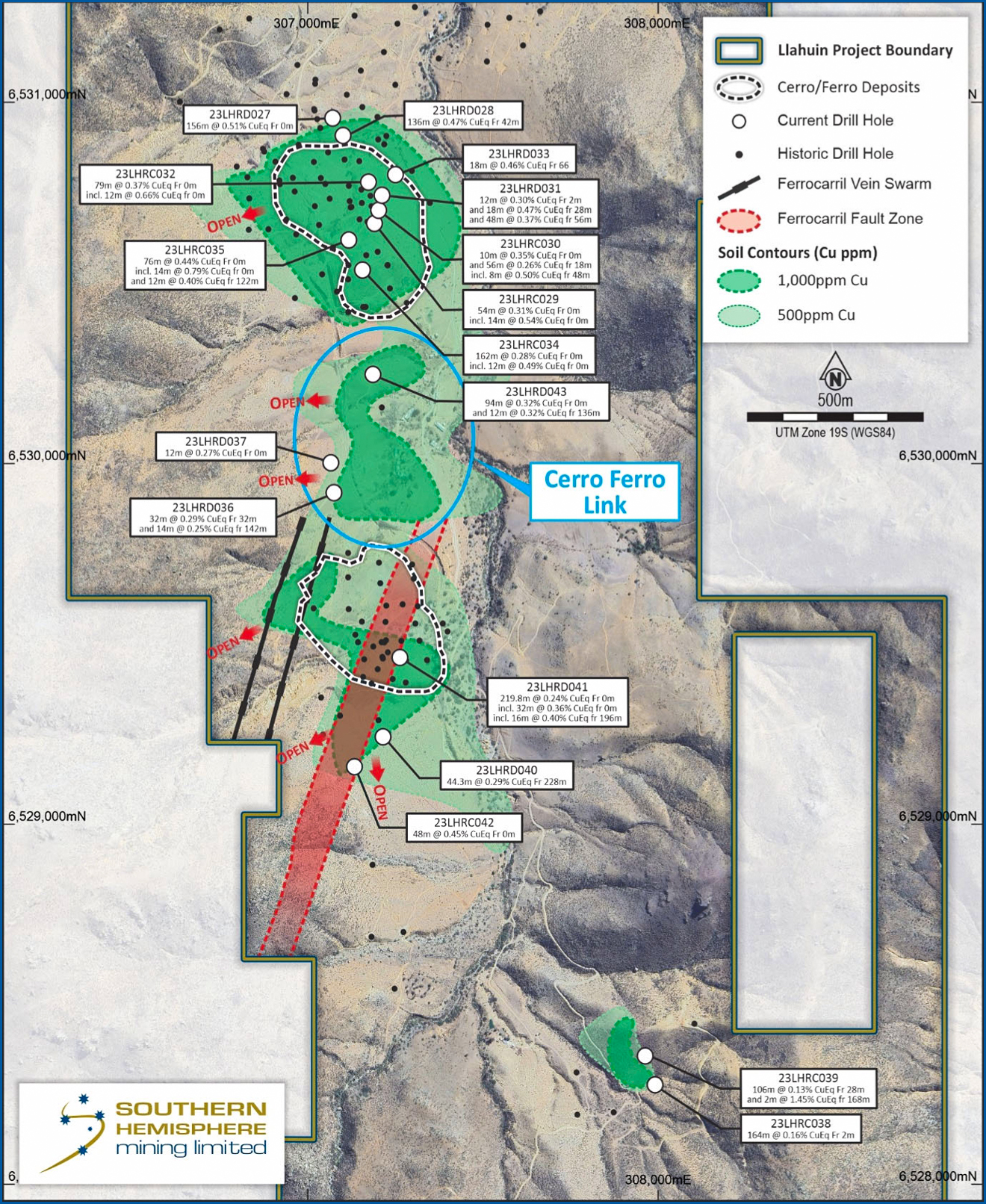
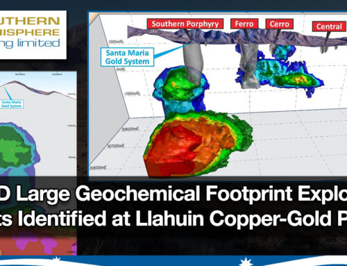
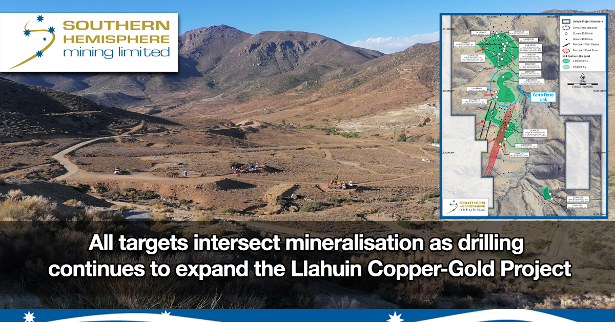
Figure 3. Plan view, showing collar locations, surface geochemical anomalies, and target models discussed in this announcement. Significant intercepts are shown in the Cerro-Ferro Link to demonstrate the exploration potential there.
Cerro Cross Sections
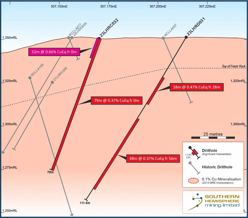
Figure 4. Cross section through 23LHRD031 and 23LHRD032.
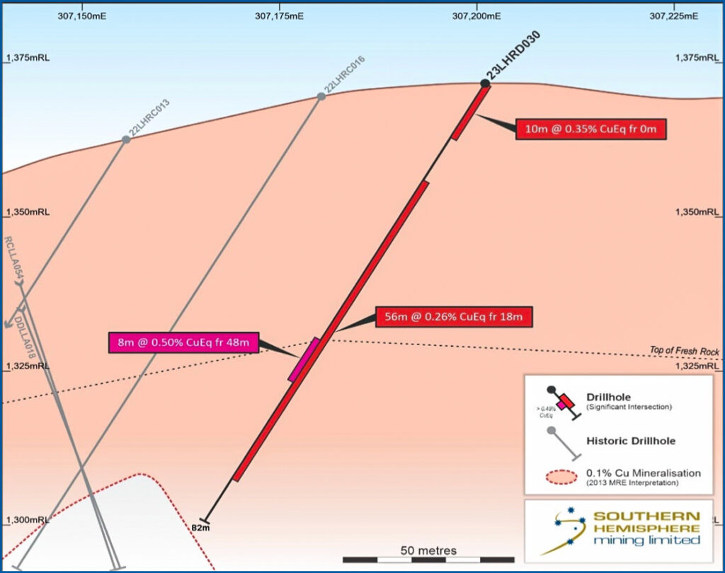
Figure 5. Cross section through 23LHRD034
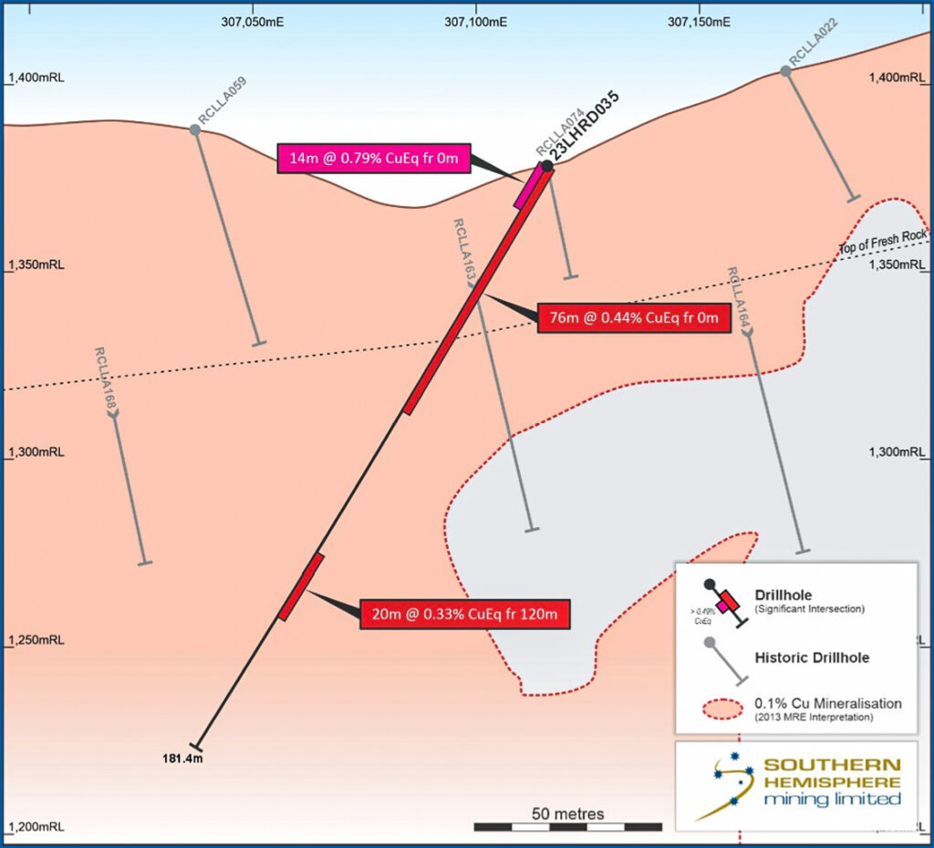
Figure 6. Cross section through 23LHRD035
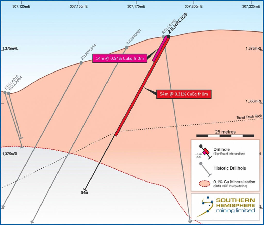
Figure 7. Cross section through 23LHRC029
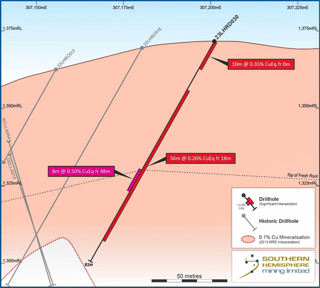
Figure 8. Cross section of 23LHRD030
⚒️ Cerro-Ferro Copper-Gold Deposits Link
These drillholes were designed to test the western edge of the link between the Cerro and Ferro deposits and confirmed the geochemistry and geophysical interpretations. Next drilling locations will be across the higher geochemical anomaly East of these holes.
Three holes were drilled in the previously untested area between the Cerro and Ferro deposits. All holes returned significant mineralised intersections. The stand-out hole was 23LHRD043, which returned 94m at 0.32% CuEq from surface.
The results in this area represent a significant upside for the Project. The surface geochemical footprint of the Cerro-Ferro Link target is approximately 600m long (NS) by 400m wide (EW).
Importantly, these findings potentially confirm that Cerro and Ferro are a single mineralised system, spanning over at least a 1.9km strike length, running North-Northeast. This not only confirms the potential to increase the near surface MRE, combining Cerro and Ferro, but provides further confidence in the concept of a root stock or feeder zone beneath providing a deeper, potentially higher-grade zone for future drilling.
- 23LHRD036, 32m at 0.29% CuEq from 32m, and 14m at 0.25% CuEq from 142m.
- 23LHRC037, 12m at 0.27% CuEq from surface at the Southern Porphyry.
- 23LHRD040, 44.3m at 0.29% CuEq to EOH from 228m.
- 23LHRD043, 94m at 0.32% CuEq, including 12m at 0.24% CuEq from 136m.
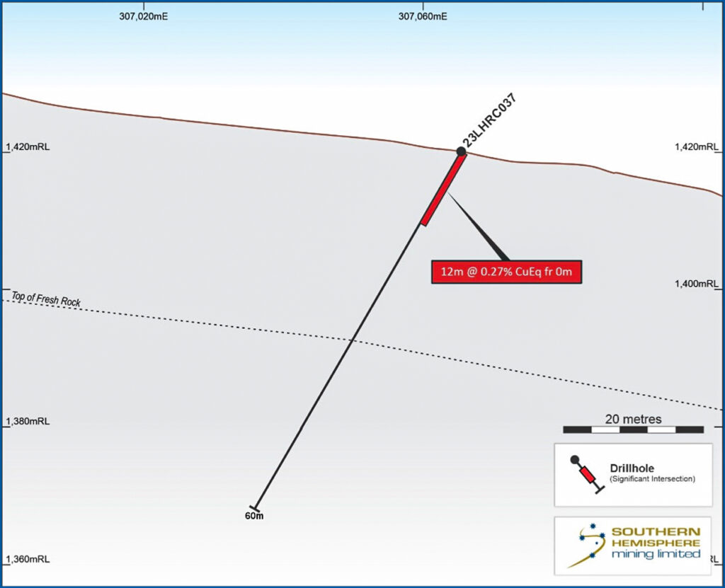
Figure 9. Cross section of 23LHRC037
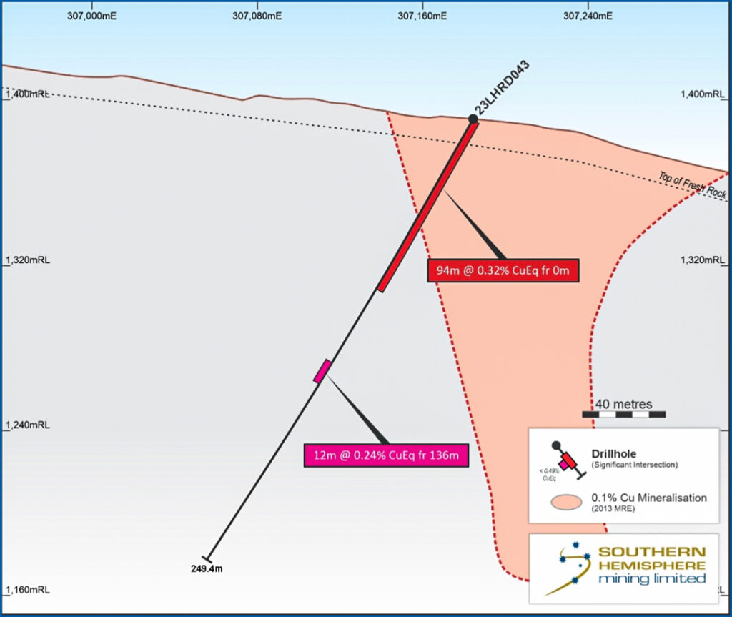
Figure 10. Cross section of 23LHRD043
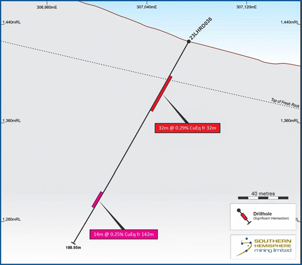
Figure 11. Cross section of 23LHRD036
⚒️ Ferro Copper-Gold Deposit
Drillhole 23LHRD041 was designed to obtain orientated core through the Ferro orebody to assist with the structural interpretation. Hole 23LHRD042 was designed to test a geochemical extension of Ferro, and intersected higher grade than the existing model and remains open to the East and South. The hole location was also testing the western boundary of the target, so future drilling will be required to the East.
The results at Ferro follow a similar theme to those already outlined at Cerro validating the new approach to drilling orientations and techniques at both deposits.
Two drillholes at Ferro 23LHRD040 and 23LHRD041, were extended to intersect an interpreted fault zone, the “Ferrocarril Fault Zone”. Both holes intersected the mineralised fault zone and ended in mineralisation. This is another high-priority target area for future drilling.
23LHRC042 extends the mineralisation at Ferro to the South. Mineralisation remains open in all directions from this position providing a significant drill target for 2024.
- 23LHRD041, 219.8m at 0.24% CuEq (from surface to end of hole), including 32m at 0.36% CuEq from surface, and 16m at 0.4% CuEq from 196m.
- 23LHRC042, 48m at 0.45% CuEq from surface.
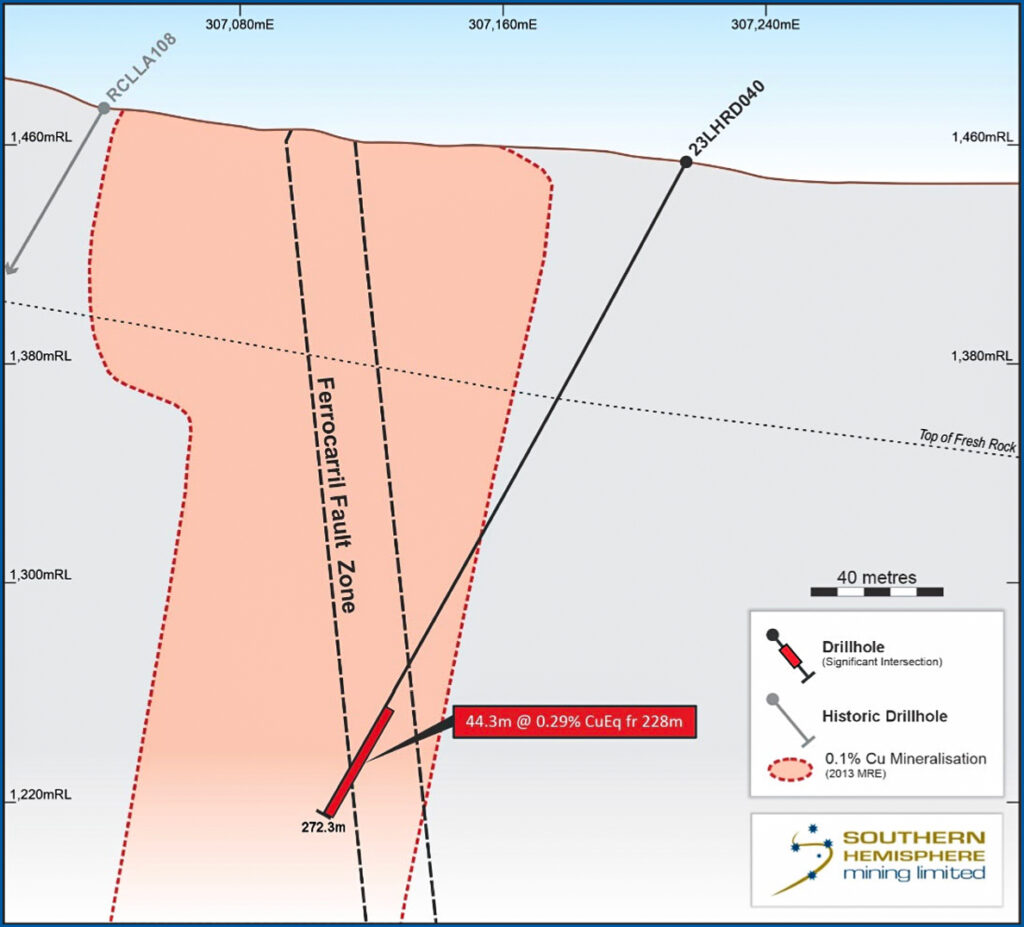
Figure 12. Cross section of 23LHRD040
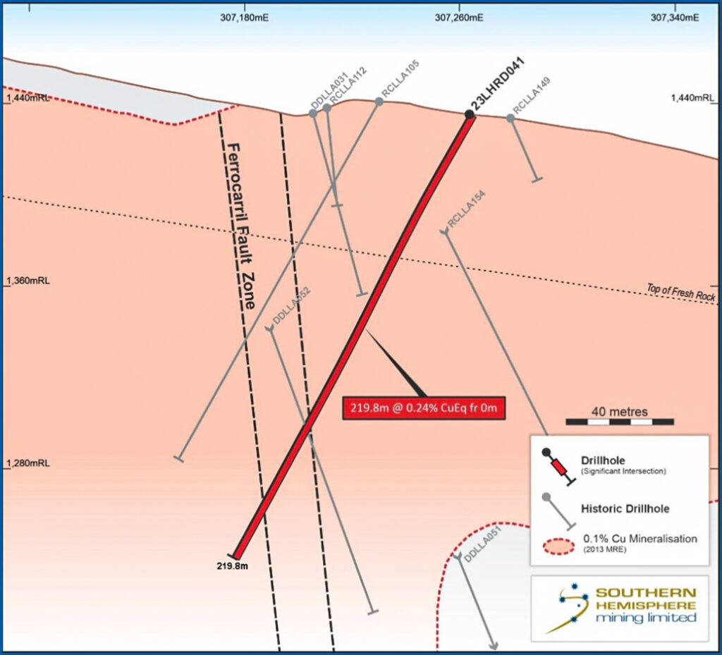
Figure 13. Cross section of 23LHRD041
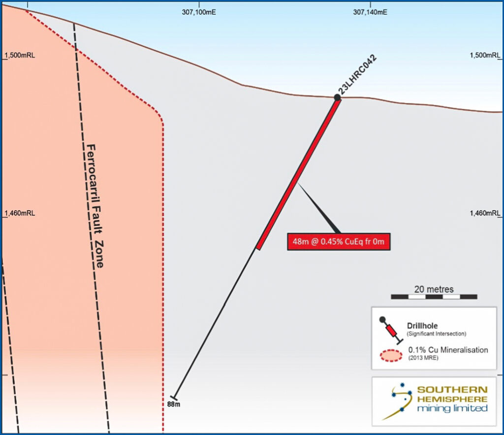
Figure 14. Cross section of 23LHRC042
⚒️ Southern Porphyry Copper-Gold Target
Two RC holes were drilled to test the Southern Porphyry target and were successful in intersecting the outer halo of this large target. The soil geochemical anomaly is likely a small vein through that area. From these results and further recent surface work 200m higher up the hill the main target is Southeast of these holes and the subject of further studies into vectoring future drillholes into the higher grade central and feeder zones.
Both holes at the Southern Porphyry intersected broad zones of mineralisation and alteration. This demonstrates that it is a large mineralising system. The drilling targeted a strong copper in soil anomaly, which represents a small portion of the larger target area in the magnetics.
Geological mapping and drill results indicate that drilling to date is located on the western side of the porphyry host target. Work is ongoing to identify the best location for follow-up drilling of this potentially extensive mineralised system.
The mapping and surface geochemistry and topography highlight the transition to gold-dominated epithermal surface showings Southeast of the known target area. These may represent additional blind porphyry targets.
- 23LHRC038, 164m at 0.16% CuEq (0.1% Cut-off) from 2m.
- 23LHRC039, 106m at 0.13% CuEq (0.1% Cut-off) from 28m, including 2m at 1.45% CuEq from 168m.
Figure 17. Map of the Southern Porphyry greater target area, showing the transition from copper dominated soil anomalies at Southern Porphyry, to gold dominated to the South.
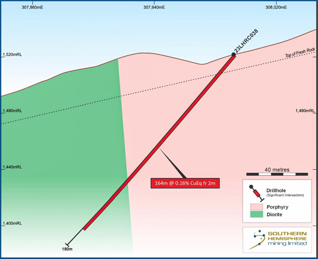
Figure 15. Cross section of 23LHRC038
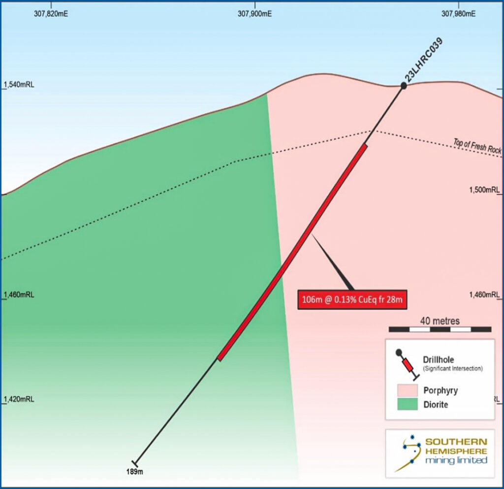
Figure 16. Cross section of 23LHRC039
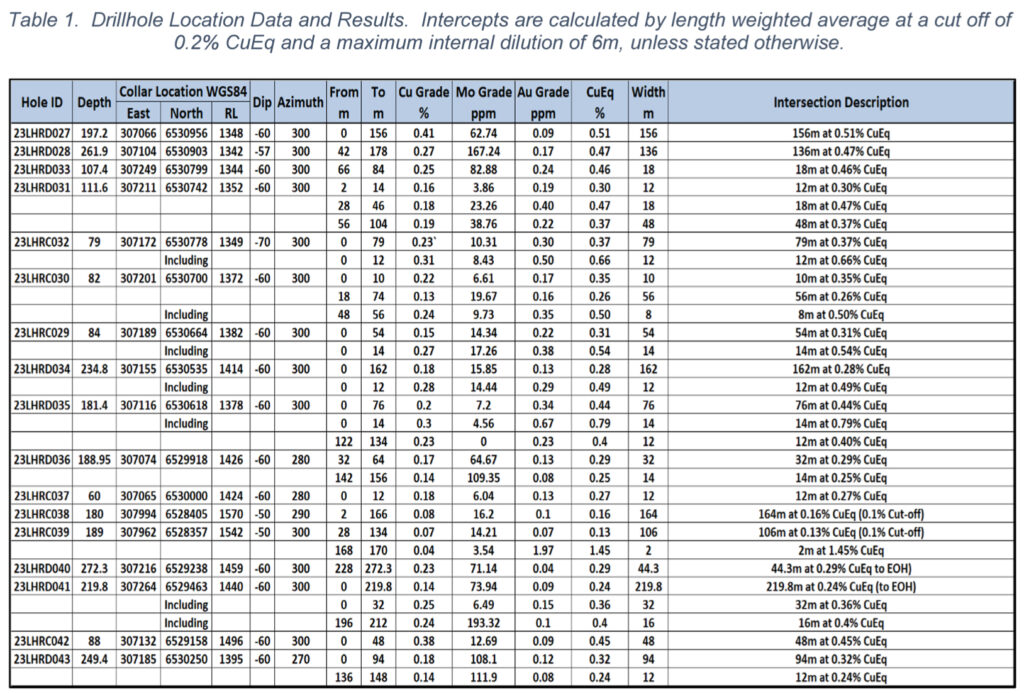
Table 1. Drillhole Location Data and Results.
Intercepts are calculated by length weighted average at a cut off of 0.2% CuEq and a maximum internal dilution of 6m, unless stated otherwise.
⚒️ Background Work, Ongoing Programs, and Findings
Systematic programs of surface geochemistry, surface mapping, structural interpretation, historical hole re-logging and multi-element assaying were used to plan the current drilling program. This lead-up work has proved critical in identifying zones for substantial expansion and drill locations.
A geological mapping program nearing completion covers the area from the Southern Porphyry to Cerro. Several key relationships and conceptual targets are emerging from this work. The full results of this program will be reported in a follow-up announcement.
Terraspec mapping of drillcore is in progress in order to produce a 3D alteration model of the deposits. In addition, a first pass batch of samples has been sent for 4 acid digestion with ICPMS finish to provide low detection limit data for 3-D “deposit footprint” modelling work.
The results of the 2023 drilling program were very encouraging.
The key findings were as follows:
- Historical drilling at Cerro and Ferro potentially demonstrates sub-optimal drilling orientations and sample bias in the historical RC drilling.
- Cerro and Ferro are part of a single mineralised system, with a potential feeder system at depth which current work is targeting to provide a future drill target.
- Southern Porphyry is a large mineralising and alteration system with the potential to host a significant copper-gold porphyry deposit.
- Shallow zones of mineralisation are open to the West and East at Cerro and Ferro.
- Mineralisation at Ferro is open to the South, Southwest, and Southeast.
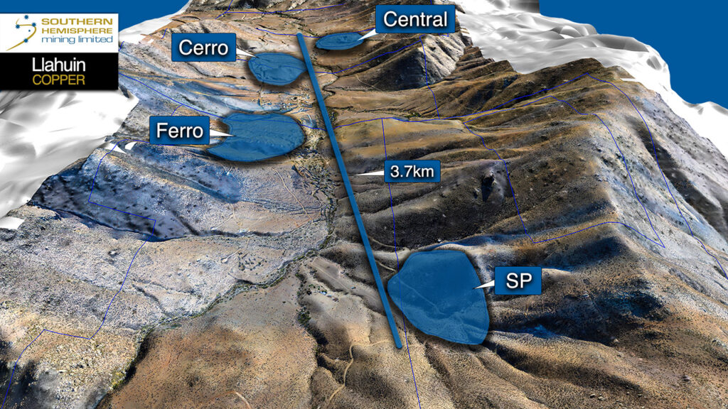
Figure 18. 3D view looking northeast from Southern Porphyry (SP) to Central Porphyry, showing the scale of the Llahuin mineralising system.
⚒️ The Company will be presenting the Llahuin Copper-Gold Project at the PDAC conference in Toronto 3-6 March 2024.
Further results will be reported in due course.
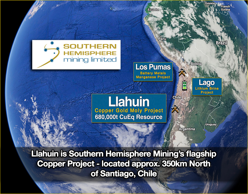
Figure 2. Location map of SUH projects in South America.
The Full PDF is available below.
News Release
Date: 19 February 2024 | ASX Code: SUH | Frankfurt Exchange: NK4
===
 Southern Hemisphere Mining Limited is an experienced minerals explorer in Chile, South America.
Chile is the world’s leading copper producing country and one of the most prospective regions of the world for major new copper discoveries. The Company’s projects include the Llahuin Porphyry Copper-Gold-Moly Project, the Lago Lithium Exploration Project, and the Los Pumas Manganese EV Battery Project, all of which were discovered by the Company.
For the latest information about the Company – please visit our Latest News and Corporate Profile pages. We are also on LinkedIn and Twitter (X).